Android and iOS Mobile Application
on
Earthquake Hazard Map of India
(A joint initiative of NDMA & BMTPC)
On the occasion of World Habitat Day celebrations, Shri Hardeep S. Puri, Hon’ble Minister of Housing & Urban Affair, Government of India, launched the Android and iOS based Mobile App on Earthquake Hazard Map of India, in the august presence of Shri Durga Shanker Mishra, Secretary, Ministry of Housing & Urban Affairs on October 5, 2017 at Vigyan Bhawan, New Delhi.
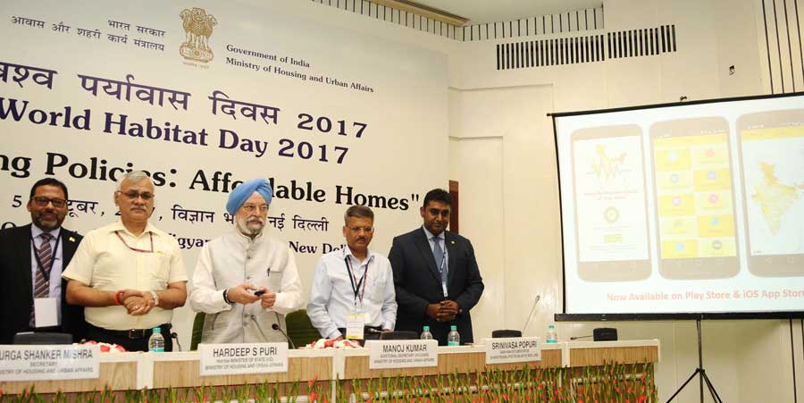
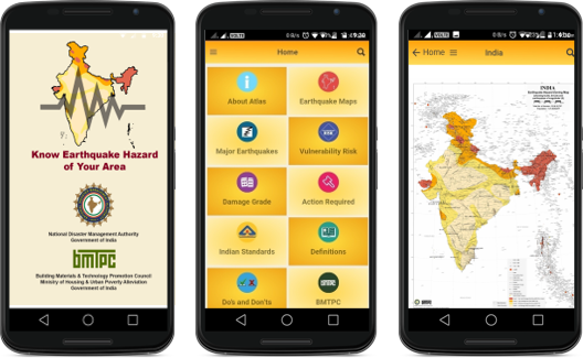
The Mobile App on “Earthquake Hazard Map of India” has been developed by BMTPC. The Mobile App is now available on the Google Play Store and Apple App Store for android and iOS users respectively. As a part of Digital India programme of Government of India, the Mobile App will be helpful in providing necessary information with regard to earthquake zonation of the country to the professionals in particular and other users in general.
Download here...
 |
|
|
Android
(Google Play Store)
|
iOS
(Apple App Store)
|
Background
Earthquakes are one of the natural hazards, which have resulted in substantial loss of lives and property in the country. The extensive damages to various structures caused by the recent earthquakes in India has made designers and planners realize the importance of realistic seismic hazard assessment and the incorporation of seismic risk reduction strategies in various aspects of urban planning and construction of structures.
The first step in working towards seismic safety of all construction is to know the seismic intensity zone in which a particular city, town or village is located, based on which necessary planning, design and construction for safety against earthquake hazard need to be adopted.
To achieve these objectives, NDMA with the technical assistance of BMTPC has brought out the Earthquake Hazard Zoning Maps of India at the country, State/UTs and District levels separately. This information can be used by every citizen of the country by looking at the District Hazard Zoning Map to know in which intensity zone his/her village falls and then to approach the knowledgeable authorities for guidance about his/her safety from a future earthquake occurrence in the area.
BMTPC undertook the project under the guidance of an Advisory Group consisting of representatives from Geological Survey of India (GSI), India Meteorological Deptt. (IMD), Survey of India (SOI), SERC Chennai, CBRI Roorkee, Earthquake Engg. Dept. IIT Roorkee and Dr. A.S.Arya, Professor Emeritus IIT Roorkee. Based on the data available from the Survey of India, Census of India, Geological Survey of India (GSI), India Meteorological Department (IMD), the earthquake hazard maps for whole country i.e. 36 states/UTs were prepared on GIS platform along with Atlas for entire India and State-wise Atlases.
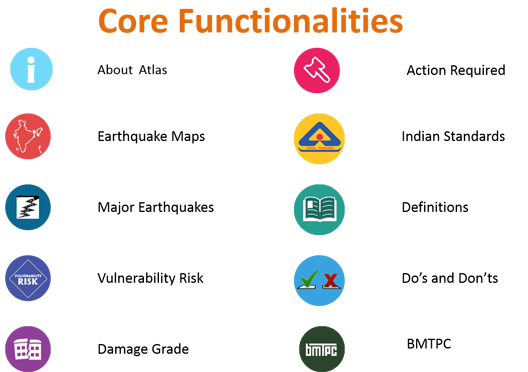
The updated Earthquake Hazard Maps and Atlases has the following components:
• Earthquake Hazard Zoning Maps for India
• Earthquake Hazard Zoning Maps for 36 States/UTs
• Earthquake Hazard Zoning Maps for all Districts
• Earthquake Hazard Zoning Atlas of India
• Earthquake Hazard Zoning Atlases for 36 States/UTs
The updated Earthquake Hazard Zoning Maps are based on :
• Seismic zones as per IS 1893 (Part1) – 2002
• District Boundary as per 2012 Survey of India data.
• Sub-division Boundary as per Census of India data.
• Epicentres of earthquakes of 4.0 and above as per IMD data
• Seismo Tectonic details as per Seismotectonic Atlas of India of GSI
The additional features in the maps are:
• Housing Data and Population data (Census 2011)
• Railway Lines
• Golden Expressway & National Highway
• Rivers & Waterbody
Usefulness of Earthquake Hazard Zoning Atlas and Maps
All major stakeholder groups i.e. leaders and policy makers, urban planners, engineers and architects, disaster management professionals, and people at large will benefit from the earthquake hazard knowledge incorporated in the maps.
These outputs will also be useful for Code Committees, architects and engineers, insurance agencies, people involved in land use planning, and, in various aspects of public and financial policies dealing with disaster mitigation and emergency planning and management.
The Mobile App provides a tool to all users to see the relevant information about Earthquake Hazard Zoning Map of India and related mitigation measures on the click of button of his/her mobile.